Runoff (R)
The term “Runoff” (R) in hydrogeology and geology refers to the part of rainfall which accumulates on the ground surface and naturally forms into flowing streams.
The term “Runoff” (R) in hydrogeology and geology refers to the part of rainfall which accumulates on the ground surface and naturally forms into flowing streams.

Terrestrial Planet Definition A terrestrial planet is any planet in the universe that has earth-like composition, such as rocks, and other similar solid substances. For instance, Mars is a terrestrial planet in our solar system, whereas Jupiter is not. This is because modern geologists, astrophysicists, and astronomers understand Mars to contain solid formations correlative to…
Gap-Graded The term “Gap-Graded” is used by geologists, engineers, and soil scientists in the geotechnical engineering field to describe the gradation of a soil sample, specifically when some particle sizes are missing. Aside from being “gap graded,” a soil sample can be described as “well-graded” (also referred to as poorly sorted), or “poorly graded” (or…
Engineering Geology or Geological Engineering Engineering Geology: Engineering geology is also referred to as “geological engineering,” and is a branch of geology that relates to the study of earth materials and processes, that are juxtaposed to proposed structures such as buildings, retaining walls, dams, roads, pipelines, and more. Whereby geologists assess any potential levels of…
Design Methane Concentration Design Methane Concentration: In accordance with the Los Angeles Department of Building and Safety Methane Code, Ordinance Number 175790, a Design Methane Concentration is the highest recorded concentration of methane soil gas detected during the course of methane testing on a property. The Design Methane Concentration is what defines the level of…
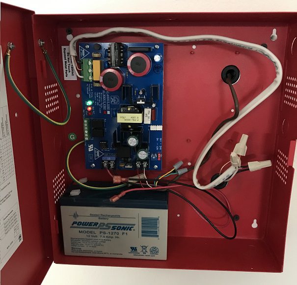
Control Panel in a Methane Mitigation System Control Panel of a Methane Mitigation System: A methane mitigation control panel is the brain behind the active mitigation system. In accordance with the Los Angeles Department of Building and Safety (LADBS) Methane Code, Ordinance Number 175790, a control panel synchronizes methane alarm units with sensors and the…
Consistency The term “Consistency” in the fields of engineering geology and geotechnical engineering means the degree of adhesion between soil particles within a sample, that are observed to resist deformation or rupture.