|

Geologic Time Scale

Geologic Time Scale

The Geologic Time Scale is an international system used by geologists to classify and identify major geologic events and formations. The geologic timescale essentially categories the earth’s entire geologic (and biologic) history, within a series of defined eons, eras, periods, epochs, and ages.

Updates & Maintenance

The geologic time scale is continuously modified and updated on the basis of breakthrough geologic research, data, and discoveries. The administration of this system is maintained by the Geologic Society of America, the International Union of Geological Scientists, the International Commission on Stratigraphy, and more. As of the year 2020, geologists understand the earth to be approximately 4.6 billion years in age. And the latest addition to the geologic time scale comprises a new “age,” referred to as the Meghalayan Age. This age signified by human-impact on the planet.

Geologic Time Scale by the Geologic Society of America

The image below references the geologic time scale published by the Geologic Society of America, as of the year 2020. Please click the image below to be re-directed to a PDF of the latest geologic time scale, directly from the Geologic Society of America website.
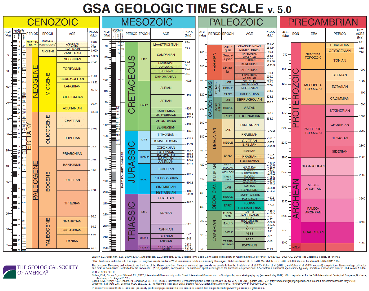
Geologic Time Scale by the Geologic Society of America

Geologic Time Scale by the International Union of Geological Scientists

The geologic time scale below is published by the International Union of Geological Scientists and is as recent as the year 2020. Please click the timescale below to be re-directed to a PDF of the latest geologic time scale, directly from the International Union of Geological Scientists’ website.
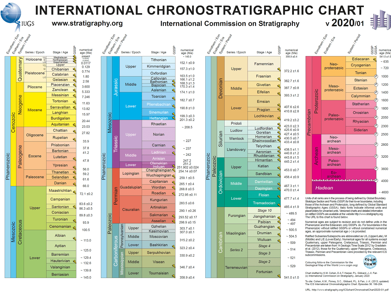
Geologic Time Scale by the International Union of Geological Scientists

Similar Posts

  • Effective Size (D10)

    Effective Size (D10) “Effective Size” (D10) is an engineering geology term. Effective Size represents a diameter that directly corresponds to the percentage, by weight, of grains that equal to 10% on the grain-size diagram. To illustrate, 10% of the soil sample particles are finer-grained, and 90% of the sample particles are coarser than the “effective…

  • Growth Fault

    Growth Fault Growth Fault: In geology, a growth fault is a strike-slip fault or dip-slip fault that moves contemporaneously with deposition. This causes the throw (amount of vertical displacement) to increase with depth and the strata to be thicker on the downthrown side as compared to the upthrown side.

  • Porosity (n)

    Porosity (n) “Porosity” (n), in the geological engineering field, is a percentage value that represents the bulk volume of a rock or soil, that is occupied by the void space within. Porosity (n) Formula Porosity (n) = [(Volume of Voids รท Total Volume) x 100%]

  • Volatile Organic Compounds (VOCs)

    Volatile Organic Compounds (VOCs) Volatile Organic Compounds (VOCs): Volatile Organic Compounds are toxic organic chemicals with higher tendencies to change from liquid to vapor phase under typical earth pressures and temperatures, and usually have little-to-no water solubility characteristics. VOCs are commonly found within hydrocarbon-based fuel additives, industrial solvents, refrigerants, hydraulic fluids, degreasers, and more. These…

  • Plat Map Definition

    Plat Map Definition Plat Map: A plat map provides the metes and bounds of a parcel in a large tract (to scale), as well as the legal land-use rights and limitations. Additionally, it demonstrates locations of streets and public utility easements, as well as ingress and egress easements. And sometimes plat maps provide information about…