Similar Posts
Hydrogen Sulfide Soil Gas
Hydrogen Sulfide Soil Gas (In Natural Gas) Hydrogen Sulfide: Hydrogen sulfide (H2S) soil gas geologically occurs upon the thermal and microbial decomposition of subsurface organic material deposits. It is typically identifiable in biogenic and petrogenic natural gas sources, along with higher concentrations of methane soil gas. Additionally, nitrogen, oxygen, hydrogen, ethane, and isobutane exist within…
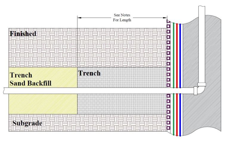
Trench Dam
Trench Dam Trench Dam: Per the Los Angeles Department of Building and Safety (LADBS) Methane Code, Ordinance Number 175790, a trench dam is part of a methane mitigation system. A trench dam is essentially a subsurface barrier that exists within a furrow or ditch, that is adjacent to the foundation of a building in a…
Confined Aquifer
Confined Aquifer Confined Aquifer: In the hydrogeology branch of geology, a confined aquifer is an aquifer that is overlain (and underlain) by a layer of low permeability, such as clay, shale, or silty clay. In fact, the two confining layers contain the storage and flow of groundwater, such that the aquifer maintains hydraulic pressure (or…
Metamorphic Rock
Metamorphic Rock Definition In the field of geology, the term “Metamorphic Rock” refers to a rock classification that is the result of the alteration of prior existing sedimentary rocks or igneous rocks. The alteration process is “metamorphosis, and can take place by various methods and environments. The metamorphosis process produces specific metamorphic rocks, on the…
Intrusive Rocks
Intrusive Rocks In the volcanology branch of geology, intrusive rocks are igneous rocks that form and crystallize under the Earth’s ground surfaces, within other geologic formations. In fact, intrusive rocks form by the process of magma shooting through pre-existing sedimentary, igneous or metamorphic rocks. For instance, a pegmatite dyke or a batholith. On the other…
Contact Metamorphism
Contact Metamorphism Contact Metamorphism – Metamorphism is associated with the intrusion of an igneous mass. Metamorphic changes are caused principally by heat, but also by magma composition and deformation related to the intrusion. Pressures are relatively low (<3000 bars) while temperatures range from 200°C to 1000°C.