Sand Boil
A “Sand Boil” is a cone-shaped deposit of sand that is formed during an earthquake. A Sand Boil occurs when subsurface sand layers liquefy and are then blown to the surface through cracks.
A “Sand Boil” is a cone-shaped deposit of sand that is formed during an earthquake. A Sand Boil occurs when subsurface sand layers liquefy and are then blown to the surface through cracks.

Time Stratigraphic Unit Definition A Time Stratigraphic Unit, or a Chronostratigraphic Unit, is a rock unit that is characterized by geological formations, during a specific period of time. This serves as a reference for all rocks formed during the same time period.
Liquefaction Liquefaction: Liquefaction is the process by which there is: (1) a sudden and significant decrease of shear resistance in a soil sample (cohesion-less); (2) a sudden (but temporary) increase of the pore-water pressure of a substance; and (3) a solid mass of soil that is transformed into a fluid state mass. In the event…
Index Fossil Definition An Index fossil, in the field of paleontology, refers to a fossil that identifies and dates the stratigraphic unit that it is observed to exist in. Index fossils can combine a wide geographic range. And they can really narrow down the classifications of most stratigraphic units.
Total Petroleum Hydrocarbons (TPH) Total Petroleum Hydrocarbons (TPH): The term “Total Petroleum Hydrocarbons” represents the complete carbon chain of hydrocarbon compounds that originate from petroleum. In general there are three ranges of TPH: Gasoline Range Total Petroleum Hydrocarbons (TPH-g); Diesel Range Total Petroleum Hydrocarbons (TPH-d); and Oil Range Total Petroleum Hydrocarbons (TPH-o). Gasoline range TPH represents the…
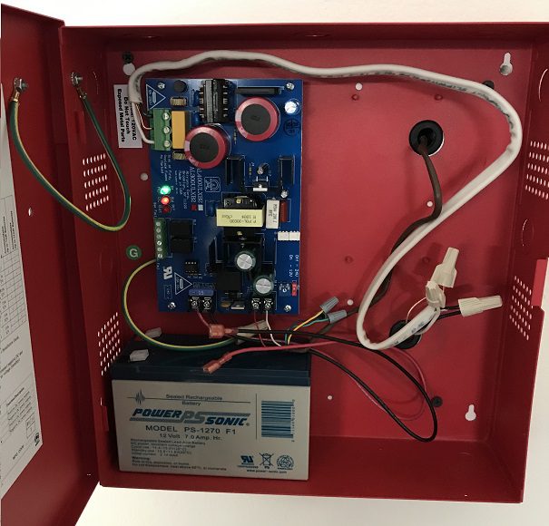
Control Panel in a Methane Mitigation System Control Panel of a Methane Mitigation System: A methane mitigation control panel is the brain behind the active mitigation system. In accordance with the Los Angeles Department of Building and Safety (LADBS) Methane Code, Ordinance Number 175790, a control panel synchronizes methane alarm units with sensors and the…
Hardpan (Caliche) “Hardpan” is a highly dense and solid layer of soil near the ground surface, which is usually comprised of clay or silty-clay soils. Hardpan forms by cementation over time, during the process of precipitation of insoluble substances such as calcium carbonates, silica, iron oxides, and other organic matter. “Hardpan” is a term mostly…