|

Geologic Time Scale

Geologic Time Scale

The Geologic Time Scale is an international system used by geologists to classify and identify major geologic events and formations. The geologic timescale essentially categories the earth’s entire geologic (and biologic) history, within a series of defined eons, eras, periods, epochs, and ages.

Updates & Maintenance

The geologic time scale is continuously modified and updated on the basis of breakthrough geologic research, data, and discoveries. The administration of this system is maintained by the Geologic Society of America, the International Union of Geological Scientists, the International Commission on Stratigraphy, and more. As of the year 2020, geologists understand the earth to be approximately 4.6 billion years in age. And the latest addition to the geologic time scale comprises a new “age,” referred to as the Meghalayan Age. This age signified by human-impact on the planet.

Geologic Time Scale by the Geologic Society of America

The image below references the geologic time scale published by the Geologic Society of America, as of the year 2020. Please click the image below to be re-directed to a PDF of the latest geologic time scale, directly from the Geologic Society of America website.
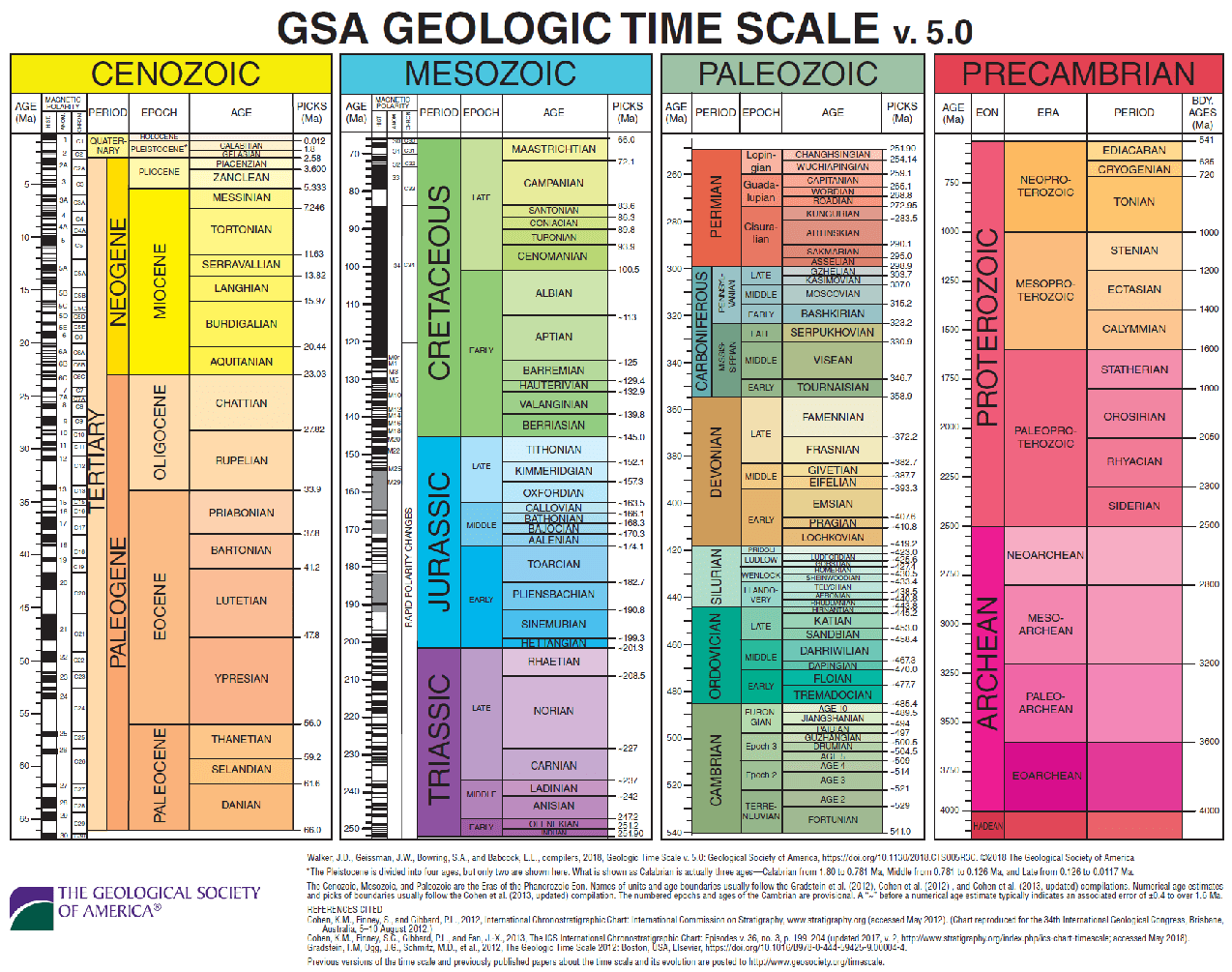
Geologic Time Scale by the Geologic Society of America

Geologic Time Scale by the International Union of Geological Scientists

The geologic time scale below is published by the International Union of Geological Scientists and is as recent as the year 2020. Please click the timescale below to be re-directed to a PDF of the latest geologic time scale, directly from the International Union of Geological Scientists’ website.
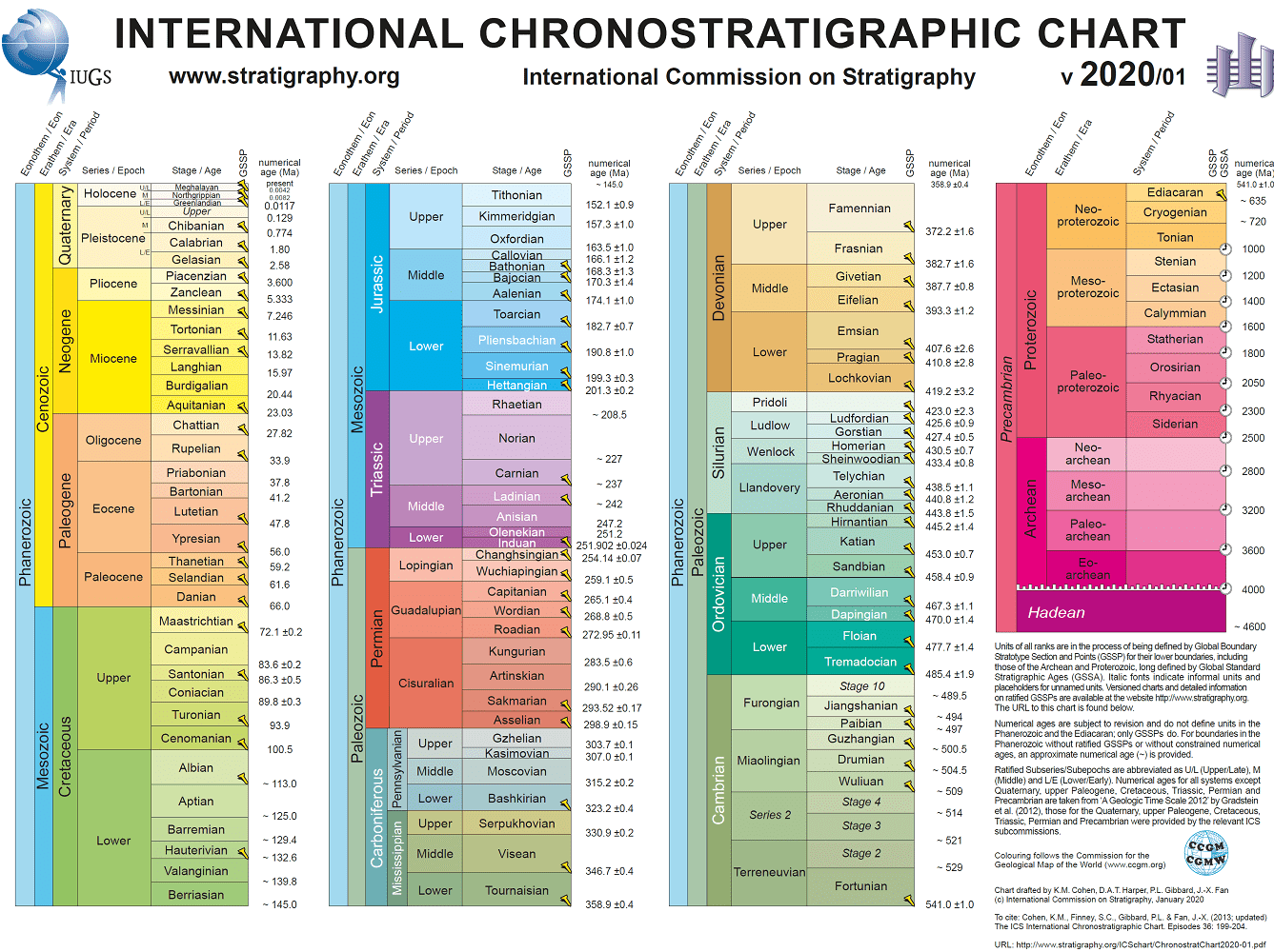
Geologic Time Scale by the International Union of Geological Scientists

Similar Posts

  • Environmental Law

    Environmental Law Environmental Law refers to the various categories of law that are put in place to protect the quality and condition of the earth and the environment. This sect of law aims to protect the well being of people and to preserve the earth’s natural resources, reserves, and wildlife. In fact, environmental laws apply…

  • Gap-Graded

    Gap-Graded The term “Gap-Graded” is used by geologists, engineers, and soil scientists in the geotechnical engineering field to describe the gradation of a soil sample, specifically when some particle sizes are missing. Aside from being “gap graded,” a soil sample can be described as “well-graded” (also referred to as poorly sorted), or “poorly graded” (or…

  • Hydraulic Conductivity (K)

    Hydraulic Conductivity (K) “Hydraulic Conductivity” (K), in hydrogeology and hydrology, represents the capacity of a porous medium (such as soil) to transmit water, as per Darcy’s Law. To illustrate, the rate at which fluid can move through a permeable medium (such as soil), depends on the properties of that soil (such as intrinsic permeability) and…

  • Aphanitic

    Aphanitic Definition Aphanitic: In geology, the term aphanitic describes the texture of plutonic or volcanic igneous rocks, with grains that are not visible to the naked eye. In fact, an aphanitic texture is usually the result of faster cooling and solidification of liquid magma.

  • Unobstructed Opening in Methane Mitigation

    Unobstructed Opening Definition in Methane Mitigation Unobstructed Opening: Per the Los Angeles Department of Building and Safety (LADBS) Methane Code, Ordinance Number 175790, an unobstructed opening is a permanent clearance or gap in the walls, floors, or ceiling of a structure, to allow for direct fresh airflow. In methane mitigation plan applications, this does not…

  • Unconfined Aquifer

    Unconfined Aquifer Unconfined Aquifer: In the hydrogeology branch of geology, an unconfined aquifer is an aquifer that has a water table. In fact, an unconfined aquifer can only be the uppermost hydrogeologic unit and is particularly one that has no hydraulic head (or pressure) that is equal to atmospheric pressure. To illustrate, depth to groundwater…