Geology of East Hollywood, Los Angeles, California & Hydrogeology
This post summarizes the basic geology of the East Hollywood region of Los Angeles California. Some geological and hydrogeological data may be incomplete or pending review. Nonetheless, students, geologists, and earth scientists are welcome to openly use, critique, and contribute information. To do so, please refer to the comments function below. Ultimately, all post data is subject to review by a professional geologist. Updated April 11, 2024.
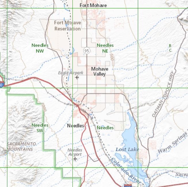
Study Area Map
The study area sits within the Hollywood, CA Quadrangle of the United States Geological Survey (USGS) 7.5-minute topographic map. In fact, this post targets the East Hollywood region of Los Angeles California.
The study area sits within the central block of the Los Angeles Basin. To the north-northwest, are the Santa Monica Mountains (nearest to the portion of Griffith Park). The Elysian Park Hills are southeast of the basin, and farther south are the Santa Ana Mountains. And the Pacific Ocean is the western boundary. The Los Angeles Basin is part of the Transverse Range Geomorphic Province. And the central block is known to include lowland portions of the coastal plain (Norris and Webb 1990).
Local Geology of East Hollywood in Los Angeles, California
The Peninsular Ranges comprise northwest-trending, strike-slip faults. Whereas the Transverse Ranges comprise east-west trending, reverse faults, and thrust faults. But the geotectonic activity of this region is controlled by the relative strike-slip fault motion of the Pacific Plate and the North American plates via the San Andreas Fault. The east-west trending structure of the Transverse Ranges province is a consequence of compression between the Pacific Plate and the North American Plate. And the rotation of the province around the “Big Bend” of the San Andreas fault system is what creates the uplift of the San Gabriel Mountains.
Alluvium Deposit
According to the Planned Utilization of the Groundwater Basins of the Coastal Plains of Los Angeles County, most of the basin sits atop a Quaternary-age alluvium formation, comprising layers of clay, silt, sand, and gravel. And these sediments are the product of fluvial deposition, via the formerly meandering Los Angeles River.
Bedrock
According to the Seismic Hazard Zone Report for the Hollywood, California Quadrangle, the alluvium overlies a shallow pre-Quaternary bedrock. The California Department of Conservation report suggests this bedrock is either the Miocene Puente Formation or the Fernando Formation (CDC 1998). These bedrocks are a series of marine and non-marine deposits of interbedding siltstones and sandstones with laminations of diatomaceous shale and siltstone. In fact, higher groundwater transmissivity in the bedrock occurs within the fracture planes (Dibblee 1989).
Shallow Soil Samples in East Hollywood, California
During recent Phase 2 Environmental Site Assessments, Soil Contamination Remediation Projects, and Engineering Geology Investigations, the following shallow observations were made in shallow soils in the study area:
- Alluvium deposit soil samples appear to be brown to reddish-brown. And from the ground surface to the top of the bedrock formation, the soil is mostly silty sand (SM). Sand grains are fine to medium and poorly graded. And the silt has medium density and plasticity.
- The top of the bedrock formation appears at various depths. In some locations, it’s as shallow as 15 feet below the ground surface. Whereas other locations don’t reveal bedrock at all as deep as 80 feet below ground surface. The bedrock is yellowish-brown and intermittently gray siltstone and sandstone. This sedimentary rock is dense sandstone with fine to medium grains. And includes layering sections of siltstone of the same color, as well as white clay.
Local Hydrogeology of East Hollywood in Los Angeles, California
Groundwater enters the basin through surface and subsurface flow. This is the result of precipitation and direct percolation, as well as streamflow. Natural replenishment of the groundwater is largely from the runoff water of the Santa Monica Mountains, and the San Gabriel Mountain. And some replenishment occurs via percolation from the Los Angeles River. Groundwater levels fluctuate due to changes in annual precipitation. Moreover, regional municipal wells pump groundwater at variable rates each quarter, further impacting the potentiometric surface of underlying confined aquifers, and unconfined aquifers.
Underlying Aquifer Systems
Some of the hydrogeological units in the study area, or the areas surrounding the study area include:
- The uppermost semi-unconfined aquifer within the quaternary alluvium.
- The Exposition, Gage, Hollydale, and Jefferson aquifers of the Upper Pleistocene Lakewood Formation.
- The Lynwood and Silverado aquifers of the Pliocene to Pleistocene Upper San Pedro Formation.
- The Sunnyside aquifer of the Pliocene to Pliestocene Lower San Pedro Formation.
Uses of Groundwater
Existing beneficial uses of groundwater within the basin of the Los Angeles Coastal Plain include municipal and domestic supply, industrial service supply, industrial process supply, and agricultural supply (RWQCB 1994).
Historically Highest Groundwater
Static groundwater occurs at depths as shallow as 14 feet below the ground surface. And according to the local Seismic Hazard Zone Report, historically highest groundwater is between 10 and 20 feet below the ground surface. Additionally, the report indicates the pre-Quaternary bedrock formation can retain groundwater within fractures plans. However, many variables can influence depth to groundwater and flow direction. And groundwater conditions may be different at various times of the year.
Depths to First Encountered Groundwater
According to the California Water Resources Control Board (SWRCB) GeoTracker Database, Cleanup Program Site “TOSCO – 76 Station” is located in the southern boundary of the study area. And this leaking underground storage tank (LUST) case is overseen by the Los Angeles Regional Water Quality Control Board (LARWQCB) as case number 900190089. In fact, groundwater monitoring reports indicate static groundwater ranges between approximately 50 and 60 feet below the ground surface.
The direction of Groundwater Flow
Shallow groundwater in this general area is understood to be variable in the flow direction, on the basis of monitoring well data and the seismic hazard report’s groundwater contour map. However, topographic relief and a larger-scale overview of the contour maps suggests groundwater generally flows north-northwest.
Methane Hazards in East Hollywood, California
The City of Los Angeles publishes maps of local methane hazard districts or zones. For instance, the LA City Methane Zone Map shows methane zones and methane buffer zones. The geology of East Hollywood, California comprises numerous subsurface pockets of petroleum deposits and natural gas, such as in the La Brea Tar Pits. These pockets also contain high concentrations of methane soil gas and hydrogen sulfide. And the study area has historically included oil drilling activities. As a result, the City of Los Angeles designates major zones of methane soil gas hazards.

Sources
California Department of Conservation (CDC). 2001. Division of Mines and Geology Seismic Hazard Zone Report for the Los Angeles 7.5-Minute Quadrangle, Los Angeles County, California, 1998, Seismic Hazard Report 029, Revised in 2006.