Hydrogen Sulfide Soil Gas

Hydrogen Sulfide Soil Gas (In Natural Gas)

Hydrogen Sulfide: Hydrogen sulfide (H2S) soil gas geologically occurs upon the thermal and microbial decomposition of subsurface organic material deposits. It is typically identifiable in biogenic and petrogenic natural gas sources, along with higher concentrations of methane soil gas. Additionally, nitrogen, oxygen, hydrogen, ethane, and isobutane exist within natural gas deposits. Hydrogen Sulfide soil gas has a rotten egg odor that commonly occurs amongst petroleum deposits, volcano craters, surfacing tar pits, and more.

What Does Hydrogen Sulfide do to the Body?

General symptoms of hydrogen sulfide exposure can include dizziness, nausea, and headaches. And a high concentration in a breathing zone can cause respiratory failure and asphyxiation issues. In fact, the Occupational Safety and Health Administration (OSHA) reports a permissible exposure limit (PEL) of 10 parts per million by volume (ppm) in worker breathing spaces. Whereas any concentration exceeding this PEL is unsafe.

Other Exposure Hazards

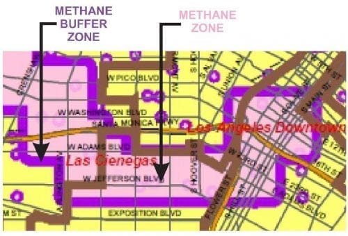
Within minutes of a person’s exposure to hydrogen sulfide, their ability to detect its odor can quickly diminish. As a result, the danger further lies with the hazards of other associated gases, as well as the lack of oxygen. For instance, a house overlaying a Los Angeles Methane Zone without a vapor barrier may have trace amounts of hydrogen sulfide and combustible methane soil gas in the lowest occupied space. And methane gas is odorless and colorless. Thus, the only human indication of natural gas intrusion is the temporary hydrogen sulfide odor. If people within the house no longer smell that odor, they may also believe the methane soil gas hazard is mitigated, under false pretenses.

Similar Posts

  • Transmissivity

    Transmissivity Transmissivity: In geology and hydrogeology, transmissivity (T) represents the capacity of an aquifer to transmit water of the prevailing kinematic viscosity. Formula T=Kb, where b = saturated thickness of the aquifer. Dimensions are gallons per day per foot (gpd/ft) or feet squared per day (ft^2/day).

  • Dry Density (ρd)

    Dry Density (ρd) “Dry Density” (ρd) is a value that represents the density of soil when it is completely dry. To illustrate, it equates to (“bulk density” / 1) + “water content.” This is a common geotechnical engineering laboratory procedure. Dry Density Formula Dry Density = [(Bulk Density ÷ 1) + (Water Content)]

  • Total Petroleum Hydrocarbons (TPH)

    Total Petroleum Hydrocarbons (TPH) Total Petroleum Hydrocarbons (TPH): The term “Total Petroleum Hydrocarbons” represents the complete carbon chain of hydrocarbon compounds that originate from petroleum. In general there are three ranges of TPH: Gasoline Range Total Petroleum Hydrocarbons (TPH-g); Diesel Range Total Petroleum Hydrocarbons (TPH-d); and Oil Range Total Petroleum Hydrocarbons (TPH-o). Gasoline range TPH represents the…

  • |

    LADBS Methane Testing Agency Roster List

    LADBS Methane Testing Agency Roster-List The LADBS Methane Testing Agency Roster-List is part of a larger alphabetical list of official companies that have certifications to work on behalf of the Los Angeles Department of Building and Safety (LADBS). The ongoing certification program is organized by the LADBS, and maintains compliance procedures and operating standards for…

  • Trench Dam

    Trench Dam Trench Dam: Per the Los Angeles Department of Building and Safety (LADBS) Methane Code, Ordinance Number 175790, a trench dam is part of a methane mitigation system. A trench dam is essentially a subsurface barrier that exists within a furrow or ditch, that is adjacent to the foundation of a building in a…

  • Well Log

    Well Log (Boring Log) Well Log: A geological well log (or boring log) is a detailed record of subsurface materials encountered during a drilling project. Boring logs, or well logs, are written by a geologist, and describe the physical subsurface characteristics and lithological units encountered during well-plotting. Well logs include information about depth, different formations,…