Long Beach, California Geology & Hydrogeology
This post summarizes the geology of Long Beach, California. However, some geological and hydrogeological data may be incomplete or pending review. Nonetheless, students, geologists, and earth scientists are welcome to openly use, critique, and contribute information. To do so, please refer to the comments function below. Ultimately, all post data is subject to review by a professional geologist. Updated April 11, 2024.
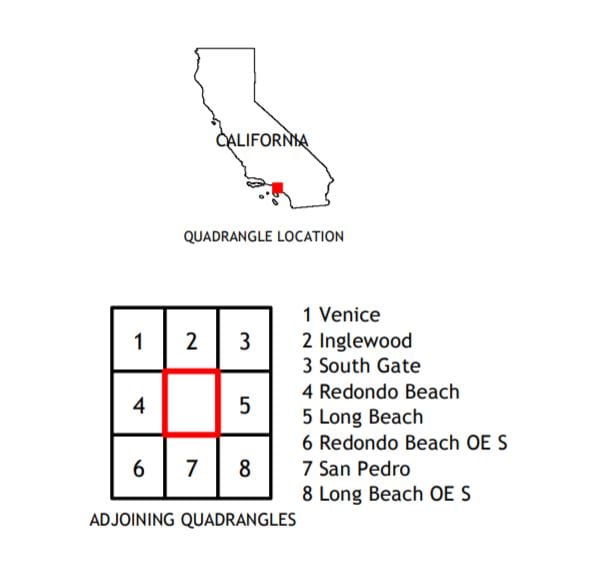
Study Area Map
The study area lies within the Long Beach Quadrangle of the United States Geological Survey (USGS) 7.5-minute series topographic map. And the general region comprises a series of hillsides and flatlands, that range from 350 feet above mean sea level (AMSL) at the hills, to 5 feet AMSL at the shoreline. Furthermore, the flatland areas appear to mostly slope southerly, towards the San Pedro Bay shoreline.

Geomorphology
The study area is within the Dominguez Gap physiographic region of the Los Angeles Basin. The basin is bounded by the Santa Monica Mountains to the north, the Puente Hills to the east, the Santa Ana Mountains to the south, and the Pacific Ocean to the west. In fact, the Los Angeles Basin is part of the Transverse Range Geomorphic Province. The central block is known to include lowland portions of the coastal plain, where the study area exists.
The study area spans southwest of the Los Angeles River and is bounded by the coastline and the Los Angeles and Orange County coastal plain areas. The study area also includes the Downey Plain, which is a large area of recent alluvial sedimentation. In fact, the Downey Plain extends from the Ballona Gap, across the Coastal Plain of Los Angeles County, and into the coastal plain of Orange County. Recent alluvial deposits within the area include sands, gravels, silts, and clays. And coarser-grain sediments exist near the inland hills, as alluvial fans and finer-grain materials accumulate near the river flood plains. The study area also consists of the Paramount Syncline, on the down block east of the Inglewood fault that is forked by two other tributary faults.
Geology of Long Beach, California
The Holocene flood-plain deposits from the Los Angeles River make up the Coastal Plain and Downey Plain, and are the youngest sedimentary formations in the geology of Long Beach. In fact, the region comprises alternating deposits of marine sand, organic muds, and fluvial sands, silts, and clays. These surface deposits typically occur as deep as 180 feet below grade. These sediments are underlain by the upper Pleistocene Lakewood Formation. The Lakewood Formations reportedly comprises 250 to 300 feet thick, layers of non-marine terrace deposits, as well as marine silt, sand, and gravel. Below the Lakewood Formation is the early Pleistocene San Pedro Formation, which is mostly layers of sand and silt. These layers are known to have interbedding characteristics.
During a series of Phase 2 Environmental Site Assessments and Methane Testing Investigations, Geo Forward oversaw the drilling and sampling of soil and groundwater samples to study the geology of Long Beach, California. Sampling activities were as deep as 25 feet below the ground surface. Per these observations,. soil samples predominantly appeared to be brown silt (ML).
Holocene Deposits in Long Beach, California
As per the USDA, Soil Conservation Service, Report, and General Soil Map of LA County, the shallow soils surrounding the study area are generally large-scale alluvial fans and floodplain materials. The Holocene flood-plain deposits contain alternating deposits of gravel, sand, silt, and clay, as deep as 180 feet below grade.
These deposits are also known to contain semi-confined and unconfined groundwater units throughout the Los Angeles Basin. Although most of these groundwater units separate via the Bellflower Aquitard, the aquitard does not frequently exist in the eastern parts of the study region. Nonetheless, these groundwater units do interconnect throughout the basin area, via a series of hydrogeologic conduits. And the semi-confined and unconfined aquifers are approximately 70 feet thick and consist of medium- to coarse-grained sand and gravel (DWR 1961).
Lakewood Formation
The surficial deposits are underlain by the Upper Pleistocene-age Lakewood Formation, which is also approximately 70 feet thick. The Lakewood Formation is non-marine and generally comprises fine to coarse-grain sand and gravel with infrequent discontinuous lenses of sandy silt and clay. The Lakewood Formation divides into two sub-units which contain the Gardena-Gage Aquifer and the Exposition-Artesia Aquifers (DWR 1961).
San Pedro Formation
The Lakewood Formation is underlain by the Lower Pleistocene-age San Pedro Formation, a well-known unit in the geology of Long Beach. The San Pedro Formation consists of an approximate 600-foot thick stratum of marine and non-marine deposits. These deposits contain gravel, sand, silt, and clay. In fact, the San Pedro Formation underlies most of the major basins within the greater Los Angeles area. It is a principal water-bearing formation for groundwater production. This formation is split into several sub-units which contain the Sunnyside, Silverado, Lynwood, and Hollydale aquifers. And the aquicludes which separate these aquifers contain fine-grain sands, silt, and clay (DWR 1961).
Pico Formation
The Pico Formation underlies the San Pedro Formation at an approximate depth of 700 feet below grade. Although contact depths may vary, as the formations generally dip towards the shoreline. The Pico Formation comprises marine deposits with medium to strong consolidation. For instance, sandstones, siltstones, limestone, and shale with interbedding layers of pebble- and cobble-size conglomerates (DWR 1961).
Long Beach, California Geology & Hydrogeology
Nearby groundwater monitoring reports suggest groundwater depths in the study area can range from 6 to 20 feet on average. And flow directions are variable However, most flow in a westerly direction.
Central Groundwater Basin
The study area sits within the Central Groundwater Basin, which extends over most of the Coastal Plain of Los Angeles County. The Central Basin is bounded on the west and south by the Newport-Long Beach uplift and on the southeast by the Los Angeles-Orange County line. On the north are a series of hills extending from the Puente Hills to the Elysian Hills (CDWR, 2003).
Groundwater enters the Central Basin through surface and subsurface flow and by direct percolation of precipitation, streamflow, and applied water in the forebay areas. Natural replenishment of the groundwater is largely from surface and subsurface inflow through the Rio Hondo and San Gabriel River spreading grounds at the Whittier Narrows (WRD 2005).
Groundwater in the Central Basin
The Newport-Long Beach Uplift acts as a partial hydrogeological barrier between the Central and West Coast Groundwater Basins. In fact, the West Coast Groundwater Basin also includes the Lakewood and San Pedro Formations.
Groundwater levels reportedly fluctuate due to changes in annual precipitation and groundwater extraction rates (WRD 2005). In fact, the current uses of groundwater within the Central Basin include municipal and domestic supply, industrial service supply, industrial process supply, and agricultural (RWQCB 1994).
Aquifers in the Central Basin
The “Central Basin Pressure Area” includes most of the southern portion of the Central Basin, and comprises aquifers that are confined by aquicludes and aquitards.
Uppermost Semi-Perched Aquifer
The near-surface aquifers presumably consist of semi-confined and unconfined aquifers of the Holocene Alluvial and wash deposits. For instance, there is the Bellflower Aquitard and the Gaspur Aquifer in the dune sands and Quaternary-age Alluvium. In fact, some of these hydrogeologic units are perched water, rather than a flowing aquifer. The Bellflower Aquiclude is a significant hydro-geologic barrier and is near the surface throughout the Central Basin Pressure Area.
Lakewood Formation Aquifers
The Lakewood Formation comprises marine and continental soils such as clay, silt, sand, and gravel from the upper Pleistocene (CDWR, 2003). It includes an uppermost semi-perched aquifer as well as the underlying confined aquifers (CDWR 1961). The underlying confined aquifers are the Gardena-Gage Aquifer, the Exposition-Artesia Aquifer, and the Jefferson Aquifer (DWR 1961, TLI 2007).
San Pedro Formation Aquifers
The Pliocene to Pleistocene San Pedro Formation mostly comprises confined aquifers. The Lynwood and Silverado aquifers exist in the upper segments of the San Pedro Formation. Whereas the Sunnyside Aquifer exists in the lower portion of the formation (CDWR, 2003).
Depth to Groundwater & Long Beach, California Geology & Hydrogeology
Many variables can influence the depths of groundwater and flow direction. However, below are two reliable sources of information, pertaining to the depths of the uppermost groundwater unit in the study area. Nonetheless, readers must know that drilling at various portions of the study area may yield results that differ from the sites below.
East Long Beach Site Data
The California Water Resources Control Board (SWRCB) GeoTracker Database reports local groundwater monitoring data from various Cleanup Program Sites in the region. In fact, “Target Service Station #698” is overseen by the Los Angeles Regional Water Quality Control Board (LARWQCB) as case number 908050670. Per the database, this site contains groundwater monitoring data from November 2007. Static groundwater levels at the Cleanup Site reportedly range between approximately 37.53 and 37.72 feet below grade. Additionally, the technical reports indicate groundwater flow towards the southeast.
West Long Beach Site Data
Another Cleanup Program Site in the region is “Former Unocal/76 Station #2999” which is overseen by the Los Angeles Regional Water Quality Control Board (LARWQCB) as case number 908020216A. According to the database files, this site contains groundwater monitoring data from January 2010. Static groundwater levels at the Cleanup Site reportedly range between approximately 32.28 and 35.11 feet below grade. Additionally, the technical reports indicate groundwater flow towards the south, at a gradient of 0.004 feet per foot.
Surface Water in Long Beach, California
The Los Angeles River trends through the Long Beach study area. No settling ponds, lagoons, surface impoundments, wetlands, or natural catch basins modernly exist.
Long Beach Fault Zone (NIFZ)
The Newport-Long Beach fault zone (NIFZ) also trends across the study area in a northwest-southeast direction. The term “fault zone” emphasizes the occurrence of a series of interconnecting faults, rather than a single fault. Moreover, tertiary and younger sedimentary rocks structurally fold and deform along the NIFZ. The Long Beach Anticline underlies Signal Hill and comprises of middle-Miocene through Pleistocene and Holocene sediments resting non-conformably on the Late Cretaceous to Late Jurassic Cataline Schist, a metamorphic rock (CDC, 1998).
Holocene-age alluvium and terrace pediment deposits are also present throughout the lower elevation areas surrounding the NIFZ. These deposits consist of dense to very dense sand and silty sand deposits (CDC, 1998).
Methane Hazards in Long Beach, California
The geology of Long Beach, California comprises massive subsurface pockets of petroleum deposits and marshlands. Because of these geologic features, the area also includes an abundance of oil and natural gas drilling activities. In fact, one of Southern California’s initial oil drilling sites commenced at the nearby City of Signal Hill, California. As a result, large quantities of natural gas and methane soil gas hazards also commonly exist in the study area.
Methane Soil Gas Intrusion Mitigation
Some nearby Cities publish maps of local methane hazard districts or zones. For instance, the LA City Methane Zone Map shows methane zones and methane buffer zones. Similarly, the nearby city of Huntington Beach produces a Methane Hazard District Map. As of September 2021, the City of Long Beach provides its own map of methane gas hazard zones. In fact, the Long Beach Building and Safety Bureau also maintains Methane Gas Mitigation standards in Chapter 18.79 of the Municipal Code.
Nonetheless, numerous Phase 2 Environmental Site Assessments in the study area indicate the presence of subsurface methane and hydrogen sulfide. Moreover, in the nearby cities of Wilmington and San Pedro, California, the LADBS does document methane zones and methane buffer zones leading to the Long Beach borders. Thus, environmental geology experts typically require a methane test and methane mitigation system for new developments in Long Beach.
Direct Sources
California Department of Conservation, Division of Mines and Geology, 1998, Seismic Hazard Zone Report 04, Seismic Hazard Zone Report for the South Gate & Long Beach Quadrangles, Los Angeles, County, California.
California Division of Mines and Geology (CDMG), 1969, Geologic Map of California, Olaf P. Jenkins Edition Los Angeles Sheet, 1969.
California Department of Water Resources (CDWR), 1961, Planned Utilization of the Ground Water Basins of the Coastal Plain of Los Angeles County, Appendix A: Ground Water Geology, Bulletin No. 104.
CDWR 1975, California’s Ground Water Bulletin No. 118, September 1975, and the October 2003 Update.
CDWR 2004, South Coast Hydrologic Region, San Fernando Valley Groundwater Basin, Bulletin No. 118.
Control Plan, Los Angeles Region, Basin Plan for the Coastal Watersheds of Los Angeles and Ventura Counties, June 13, 1994.
Regional Water Quality Control Board (RWQCB), 1994, Final Draft – Water Quality Control Plan, Los Angeles Region, adopted June 13, 1994.
United States Department of Agriculture, Soil Conservation Service (USDA-SCS), 1961, Revised 1969, Report and General Soil Map, Los Angeles County, California.
Secondary Sources
United States Geological Survey (USGS). 2005 Preliminary Geologic Map of the Los Angeles 30’ x 60’ Quadrangle, California, Open-File Report 2005-1019, Version 1.0, dated 2005.
USGS 2015: 7.5-minute Topographic Map, of the South Gate, California Quadrangle, USGS.
USGS 2015: 7.5-minute Topographic Map, of the Long Beach, California Quadrangle, USGS.
California Department of Conservation 2001. Division of Mines and Geology Seismic Hazard Zone Report for the Long Beach 7.5-Minute Quadrangle, Los Angeles County, California, 1998, Seismic Hazard Report, Revised in 2006.
RWQCB 1994m Final Draft – Water Quality Control Plan, Los Angeles Region, adopted June 13, 1994.