Underground Storage Tank (UST)

Underground Storage Tank (UST)

Underground Storage Tank (UST): An underground storage tank (UST) is a confined container occupying any volume of space within the subsurface, for the purposes of storing liquid. Underground tanks typically support commercial and residential services and have filling ports, ventilation pipes, and connecting product pipelines. Underground storage tanks (USTs) come in different sizes and are made with various materials (for example- fiberglass, steel, plastic, polymer, or combinations of these in the form of double walling).

Underground Storage Tank Abandonment & Removal Process - Geo Forward
Underground Storage Tank Abandonment & Removal Process – Photo by Geo Forward

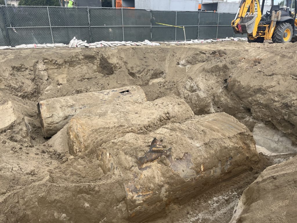
Environmental Conditions of Underground Storage Tanks

Commonly, USTs are used to contain hazardous liquids, such as gasoline, diesel, jet fuel, waste oil, heating oil, etc. As a result, underground tank contamination is a recognized environmental condition. And the underground storage tank removal process entails mandatory environmental compliance. Moreover, modern environmental laws require certain facilities to maintain leak detection systems, vacuum and pressure sensors, and subsurface secondary containment units with USTs to prevent UST soil pollution.

Also See:

Similar Posts

  • Hydraulic Head

    Hydraulic Head Hydrualic Head: In the field of hydrogeology, hydrualic Head is a measure of the potential energy of a fluid at any given point in a hydraulic system. It explains the potential energy driving fluid flow by summing the elevation of the fluid and the pressure it exerts.

  • Dry Density (ρd)

    Dry Density (ρd) “Dry Density” (ρd) is a value that represents the density of soil when it is completely dry. To illustrate, it equates to (“bulk density” / 1) + “water content.” This is a common geotechnical engineering laboratory procedure. Dry Density Formula Dry Density = [(Bulk Density ÷ 1) + (Water Content)]

  • Regression

    Regression Regression: In geology, regression is the formation of a specific sequence of sedimentary and metamorphic layers, that are the result of ocean water withdrawing from the land. To illustrate, when regression occurs over millions of years, geologists find a layer of limestone, overlain by shale, and overlain again by limestone. The opposite of regression is…

  • Fault Scarp

    Fault Scarp Fault Scarp: In the field of geology, a dip-slip fault scarp is a steep slope that is formed directly by fault movement. It occurs along the line of a normal fault, reverse fault, or transform fault. A fault scarp represents the planer surface of the fault before erosion and weathering modify it.

  • Hydraulic Conductivity (K)

    Hydraulic Conductivity (K) “Hydraulic Conductivity” (K), in hydrogeology and hydrology, represents the capacity of a porous medium (such as soil) to transmit water, as per Darcy’s Law. To illustrate, the rate at which fluid can move through a permeable medium (such as soil), depends on the properties of that soil (such as intrinsic permeability) and…