Methane Mitigation Soil Gas Pressure Sensor

Methane Mitigation Soil Gas Pressure Sensor

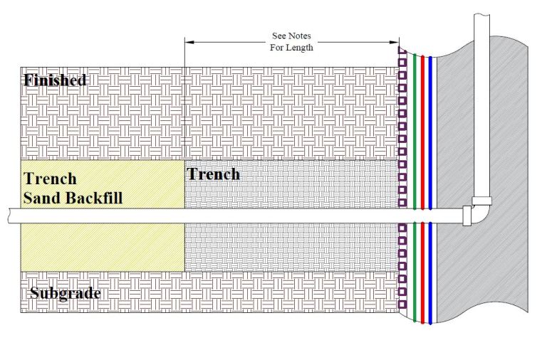
Methane Mitigation Soil Gas Pressure Sensor: A Methane Mitigation Soil Gas Pressure Sensor is a device that measures and communicates sub-slab soil gas pressure to a methane control panel system. High levels of methane soil gas then trigger the integrated methane alarm system to notify occupants of danger. Much like the process of a methane soil gas test, this sensor records earth-induced pressure, as well as hydrocarbon gas concentrations. In fact, these parameters are necessary for site design level determination, as well as proper methane mitigation.

Methane Mitigation Soil Gas Pressure Sensors are typically part of an active mitigation system. They are set by professional vapor barrier installers, usually above the gravel blanket and methane barrier but below the finished concrete slab. In addition to biogenic and petrogenic natural gas, geologists use these sensors and probes to measure other toxic vapors, such as various volatile organic compounds (VOCs).

Methane Mitigation Soil Gas Pressure Sensor
Methane Mitigation Soil Gas Pressure Sensor – Photo by AAK Geo Forward

Similar Posts

  • Dry Density (ρd)

    Dry Density (ρd) “Dry Density” (ρd) is a value that represents the density of soil when it is completely dry. To illustrate, it equates to (“bulk density” / 1) + “water content.” This is a common geotechnical engineering laboratory procedure. Dry Density Formula Dry Density = [(Bulk Density ÷ 1) + (Water Content)]

  • Geosyncline

    Geosyncline Geosyncline: In geology, a geosyncline is a large-scale indentation in the Earth’s crust that is filled with sediments. A geosyncline forms due to the gradual sinking of the Earth’s crust, causing sediment from adjacent areas to gather inside. An example of a geosyncline is the Appalachian Mountains.

  • Rigidity

    Rigidity Definition Rigidity – In geotechnical engineering and engineering geology, rigidity represents the ratio of the shear stress and the amount of angular rotation that it produces, within a rock sample.

  • Facies

    Facies Facies: In the field of geology, the term “facies” represents a mappable, areally restricted part of a rock body that has different fossils or lithology from other contiguous beds deposited at the same time.

  • Well Log

    Well Log (Boring Log) Well Log: A geological well log (or boring log) is a detailed record of subsurface materials encountered during a drilling project. Boring logs, or well logs, are written by a geologist, and describe the physical subsurface characteristics and lithological units encountered during well-plotting. Well logs include information about depth, different formations,…

  • Design Methane Pressure (Soil Formation Pressure)

    Design Methane Pressure (Soil Formation Pressure) Design Methane Pressure or Soil Formation Pressure: As per the Los Angeles Department of Building and Safety (LADBS) Methane Code, Ordinance Number 175790, Design Methane Pressure means the highest observed measurement of soil formation pressure during the methane testing process. In fact, a Design Methane Pressure measurement that is…